The Boundary That the Landscape Does Not Mark
Learn how to read a regional boundary the landscape does not mark, distinguish its administrative purpose from physical terrain, and describe both precisely.
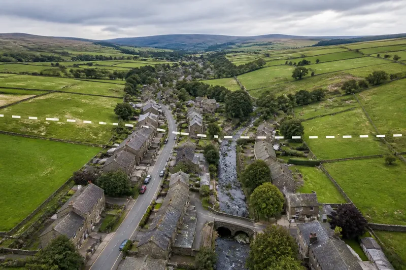
You can cross a regional boundary on a footpath without noticing a change in the fields around you. A map may show a crisp line, while hedges, slopes and buildings continue without interruption. To read that boundary well, identify what it separates and check whether the land itself offers any visible divide.
A boundary is a defined limit between places or areas. It may mark a council, county or district, or describe a region used for geographical or cultural purposes. A river or ridge can coincide with such a line, but a mapped boundary can also cross level ground or pass through a settlement. Its meaning depends on the map’s purpose.
Map purpose
Start by asking what the map is intended to show. An administrative map marks areas with governing responsibilities. A regional map may describe a landscape or a sense of place. A walking map might include a parish edge as a location reference, while a historical map can preserve a line whose administrative role has changed.
Read the title, legend and date, and check whether the boundary is named. A thick line, dashed line or faint tint has no universal meaning across all maps. If the map does not explain its symbols, treat the line’s purpose as uncertain rather than inferring it from appearance alone.
Choose the right source
Match the source to the question you need answered. A boundary can matter for one purpose and be irrelevant for another.
- Administration: Check a current official map or address lookup. If it identifies the authority responsible for the place, use that result for civic questions; if it does not, check with the relevant local authority rather than relying on a scenic map.
- Landscape: Observe features such as a watershed, slope or valley floor. If these form a continuous landform, describe that feature; if they do not align with the mapped line, keep the terrain description separate from the regional boundary.
- Walking: Compare the map with paths, roads, gates and field edges. If the route crosses the boundary without an obstacle, describe it as a map line rather than a barrier; if a fence or road changes access, describe that feature instead.
- Local identity: Notice how people name places on both sides. If local accounts connect them, allow for shared identity across the line; if accounts differ, describe those differences without treating either as universal.
- Historical comparison: Check the date and purpose of each map. If the line changes between maps, identify the change in the mapped boundary; if the dates or map purposes differ, do not treat the comparison as evidence of a changed landscape.
Say you are describing a village that straddles a county boundary. The road, stream and rows of houses continue across the mapped line. You could check an official address lookup to establish which authority covers each address, then describe the visible settlement as connected. The result distinguishes civic responsibility from the physical pattern of the village.
Ground evidence
Natural features can make boundaries easier to recognise, but they do not settle every question. A ridge may mark a watershed, yet an administrative line can cross it or run along one side. A river may appear to divide its banks, while bridges and paths connect them. A drainage divide can also be difficult to see across gently rising fields.
Use observations to describe how the boundary relates to its setting. For each check, decide what the result supports:
- If the line follows a continuous stream, ridge or coast, describe that alignment; if it cuts away from the feature, keep the mapped boundary and landform distinct.
- If the line crosses fields, streets or a settlement without a marker, describe it as an unmapped-on-the-ground division; if a visible feature marks it, name that feature without assuming it is the official boundary.
- If a sign or boundary stone names the relevant authority or area, use it as supporting evidence; if it names something else or is unclear, do not use it to identify the line.
- If a path crosses freely, describe the boundary as no physical obstacle to that route; if a gate, fence or road shapes movement, describe that access feature separately.
- If the legend labels the line as administrative, use that description; if the legend calls it a landscape region or gives no explanation, seek a suitable source before assigning a more exact meaning.
- If an official map or address lookup identifies the relevant limit, use it for general orientation; if the exact status of land or a property matters, contact the responsible authority or a qualified professional.
Visual clues can help explain a boundary’s relationship to the landscape, but they cannot establish a legal limit by themselves. For a property or land-status question, consult an authoritative source or seek qualified advice.
Why cross open ground?
A boundary can cross open ground because it marks an administrative or descriptive division rather than a natural edge. Its course may reflect the purpose and history of the area being mapped, not a ridge, river or visible change in terrain. Without a reliable source for that history, describe what the map shows and avoid guessing why the line was drawn there.
Questions about boundaries?
Does every boundary follow a river or ridge?
No. Some boundaries follow natural features, while others cross fields, roads or built-up areas. The map’s purpose tells you what the line represents; the terrain does not determine its meaning on its own.
Can a boundary be invisible on the ground?
Yes. Many administrative boundaries have no physical marker, so the landscape can look unchanged as you cross them. A suitable map may still show a division used for governance or record-keeping.
How can I tell which side a place is on?
Use a map that names the relevant boundary and fits your question, then check the location with a reliable address or place lookup. Small-scale maps may simplify lines, so do not treat a screen position as an exact property limit.
Is a regional boundary the same as a cultural divide?
Not necessarily. A mapped regional label can describe an area, while language, work, family ties or traditions may extend across its edge. State which sense of “region” you mean, rather than treating the line as proof of a shared or separate identity.
Describe the line
Use wording that separates what the map shows from what the land reveals. You might say that a road crosses an administrative boundary or that a village lies at the edge of a mapped region. For terrain, name the visible feature: the valley broadens, the slope softens or the stream bends through the fields. Do not say the landscape ends at a boundary unless a distinct physical change occurs there.
Keep three kinds of statement separate. A mapped boundary is a line shown by a particular source. A physical feature is observable in the terrain. Regional identity is a way people may describe belonging, and views can differ. These ideas can overlap, but none proves the others.
When reading a regional boundary the landscape does not mark, keep the map’s purpose in view. Use an appropriate official source for administration, describe visible landforms as terrain, and allow for identities that cross the line. That distinction helps readers understand both what the boundary represents and what it leaves out.